[:he]* 
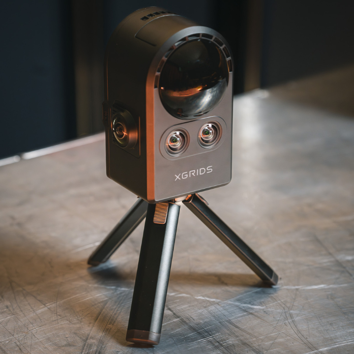
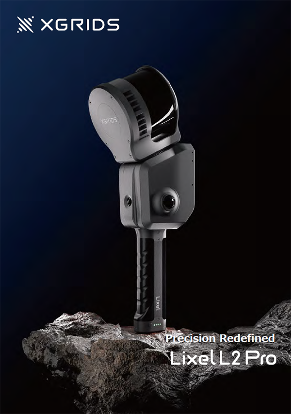
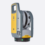
מכשיר מתקדם, חדשני ומהפכני בתחום סריקות הלייזר – 3D LIDAR
* סורק לייזר נייד משולב מצלמת HD למדידה, מיפוי ומידול בתלת מימד
* סורק ייעודי, איכותי, ומתקדם לסריקה לטווח של עד 30 מ' וללא כל מגבלה ולביצוע עבודות מדידה ומיפוי מורכבות תוך שהייה קצרה בשטח וביטול הצורך לחזור לשטח להשלמות ו/או למדידה חוזרת.
* אין צורך בקליטת GPS: מתאים למדידה indoor ו- outdoor
* מדידה של 43,200 נקודות בשניה וברזולוציה של 3 ס"מ
* הצגה בזמן אמת של תוצאות הסריקה על גבי מסך מגע בגודל 7"
* מיפוי תלת מימדי קל ומהיר של חללים מורכבים, נכסים ודירות מאוכלסים, אולמות ייצור, מערכות תשתית, מנהרות תשתית, אתרי ארכיאולוגיה ועוד
* יכולת ליצור ולהפיק מגוון של תוצרי מיפוי מפורטים, בדו-ממד ובתלת-ממד כולל מודלים תלת-ממדיים פוטוריאליסטיים
* חסכון רב בזמן ובעלויות – יחס עלות תועלת גבוה מאוד
* אלגורתמים מתקדמים למיפוי ולמידול תלת ממדי אוטומטיים
* העבודה עם CONTOUR קלה ופשוטה הן בהפעלה והן ביישום ואינה דורשת מיומנות מיוחדת. ממשק עבודה אינטואיטיבי וקל לשימוש ללא צורך בהגדרת פרמטרים מורכבים לביצוע סריקה
* גמישות בהפעלה – אפשר להפסיק את הסריקה ולהמשיך בכל עת ללא הגבלה
* תיעוד והצגה של מסלול הסריקה
* ייצוא מהיר וקל של תוצרי הסריקה לתוכנות CAD ולפורמטים las, ply
* יכולת עבודה עם מגוון תוכנות וצפיינים (viewers)
* תוצרי המערכת:
- ענן נקודות וקטורי תלת מימדי (3D Point Cloud ), מפורט, צבעוני ומלא של כל המרחב הנסרק
- תצלומים איכותיים וברזולוציה גבוהה
- מודל תלת ממדי פוטו-ריאליסטי
- מסלול הליכה/סריקה
KAARTA CONTOUR – הדרך הקלה והמהירה למדידה ולמיפוי בתלת מימד
ה- CONTOUR מאפשר לבצע עבודות מדידה ומיפוי במגוון תחומים ובהם:
- תכנון: ליווי של תהליכי תכנון ובכלל זה מדידה ומידול בתלת-ממד של מבנים קיימים
- בנייה: סריקת לייזר מדויקת תוך כדי התקדמות הבנייה לאיתור אי התאמה לתכנון, הפקת מודל תלת מימדי וחתכים של המבנה לאחר גמר ביצוע (As-Made)
- שימור מבנים: סריקת לייזר תלת ממדית מדויקת וברזולוציה גבוהה כולל צילום קרקעי של המבנה כולל של אלמנטים אדריכליים לתיעוד ולשימור.
- ארכיאולוגיה: מדידה וסריקת לייזר מדויקת של האתר הארכיאולוגי לצורך תיעוד, שימור כולל מידול תלת-ממדי. תיעוד וליווי עבודות החפירה הארכיאולוגית והחישוף. מדידה לצורך מעקב אחר תזוזה/שקיעה של מבנים ארכיאולוגיים. מדידה של מערות, מערות נטיפים וכד'.
- יציבות מבנים ומעקב: ביצוע סריקות לייזר במועדים שונים לאיתור תזוזות ושקיעות, הן של מבנים, קירות, קירות תומכים וכד'.
- תעשייה: מדידה ומיפוי של מערכות תשתית מורכבות ואולמות ייצור, מדידה מדויקת לצורך כיול, כיוון ו/או הצבה, מדידה של מיכלים לצורך כיול ו/או איתור דפורמציות
- תשתיות: מדידה ומיפוי של מנהרות תשתית, מחצבות.
סורק לייזר איכותי לעבודות חזית, עבודות פנים, חקירות, עבודות חוץ, סריקת כבישים, ביקורת בדיוק של מילימטרים, מיפוי מצבי מדויק ומציאת סטיות בקירות או מבנים אחרים.
______________________________________________________________________________________________________
Axis משווקת ציוד מדידה איכותי, אצלנו תמצאו מגוון מכשירי מדידה למודדים וקבלנים, מערכות מידע גיאוגרפיות, כלים למיפוי, מכשירי ניווט, מיפוי אווירי, פוטוגרמטריה, פתרון לתצלומי אוויר, בתימטריה ופתרונות נוספים.
באקסיס תוכלו למצוא בין היתר: מכשירי GPS וקלטות, מערכות GIS, סורקי לייזר, רחפנים ותוכנות לעיבוד ענן נקודות, דיסטומטים (מד קואורדינטות), מיפוי בעזרת מציאות רבודה, כלים למיפוי ימי, מיפוי נע, מערכות שליטה על כלים, ניטור, פתרונות מיקום מתקדמים, רשת VRS, מאזנות אופטיות ולייזר ועוד.[:en]
MAPPING ON THE MOVE
A WHOLE NEW APPROACH TO REALITY CAPTURE
REAL TIME VIEWING AND CONTROL
INTELLIGENT ASSISTANCE TO GET THE SCAN RIGHT
COLORIZED POINT CLOUDS
ON-BOARD ASSISTANCE
In addition to Reality Layer, Kaarta continues to provide rich and sophisticated software updates, all free to existing and new customers.
- Transition Mapping Mode dramatically eliminates many alignment issues associated with room transitions such as doorways during scanning. Other transitions such as the “opening up” at the end of an aisle in a warehouse, turns in hallways, and stairwells all benefit from this new feature.
- Stop Adding Points prevents the unwanted addition of a moving object, such as a person entering the scanning area, to the model. It also can be used in difficult transitions while scanning such as turning around in a narrow space, opening a door, or retracing through an already mapped space.
- Expandable Camera View allows the user to customize the on screen view to suit the application.
- Save Color Images enables tagging and labeling of color images and is particularly useful for capturing notes during scanning.
- Scan Detail includes an array of information about the scan, cover photos, editable notes fields, viewing, converting and copying file management functions, and access to post-processing functions for Reality Layer.
- Improved Startup Initialization intelligently builds a better base for the mapping process, reduces early errors, and provides better gravity alignment.
- Resume/Replay allows you to load and extend the current map or replay the scan.
- Color Imaging improved auto-exposure responds to varying lighting conditions.
- Error Reporting during scanning alerts users if there is a mapping sensor failure or processing failure and will automatically pause and rewind to the last good mapping result, allowing the user to try to resume or end the scan and save the already scanned data.
KAARTA ENGINE

Kaarta Engine, Kaarta’s patent-pending advanced 3D mapping and localization algorithms, is at the heart of Contour, providing highly accurate and robust maps.
Contour is ideal for scanning as-built multi-room interiors, multi-floor plans, buildings, industrial plants and infrastructure and more for both planning and maintenance purposes.
[:ar]
MAPPING ON THE MOVE
A WHOLE NEW APPROACH TO REALITY CAPTURE
REAL TIME VIEWING AND CONTROL
INTELLIGENT ASSISTANCE TO GET THE SCAN RIGHT
COLORIZED POINT CLOUDS
ON-BOARD ASSISTANCE
In addition to Reality Layer, Kaarta continues to provide rich and sophisticated software updates, all free to existing and new customers.
-
Transition Mapping Mode dramatically eliminates many alignment issues associated with room transitions such as doorways during scanning. Other transitions such as the “opening up” at the end of an aisle in a warehouse, turns in hallways, and stairwells all benefit from this new feature.
-
Stop Adding Points prevents the unwanted addition of a moving object, such as a person entering the scanning area, to the model. It also can be used in difficult transitions while scanning such as turning around in a narrow space, opening a door, or retracing through an already mapped space.
-
Expandable Camera View allows the user to customize the on screen view to suit the application.
-
Save Color Images enables tagging and labeling of color images and is particularly useful for capturing notes during scanning.
-
Scan Detail includes an array of information about the scan, cover photos, editable notes fields, viewing, converting and copying file management functions, and access to post-processing functions for Reality Layer.
-
Improved Startup Initialization intelligently builds a better base for the mapping process, reduces early errors, and provides better gravity alignment.
-
Resume/Replay allows you to load and extend the current map or replay the scan.
-
Color Imaging improved auto-exposure responds to varying lighting conditions.
-
Error Reporting during scanning alerts users if there is a mapping sensor failure or processing failure and will automatically pause and rewind to the last good mapping result, allowing the user to try to resume or end the scan and save the already scanned data.
KAARTA ENGINE
Kaarta Engine, Kaarta’s patent-pending advanced 3D mapping and localization algorithms, is at the heart of Contour, providing highly accurate and robust maps.
Contour is ideal for scanning as-built multi-room interiors, multi-floor plans, buildings, industrial plants and infrastructure and more for both planning and maintenance purposes.
[:]