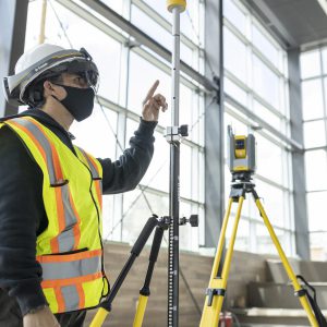
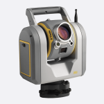
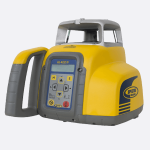
דיסטומט עוצמתי עם הטכנולוגיות המובילות בעולם המדידות .
ה-FOCUS 35 הוא דיסטומט המספק מהירות עבודה ודיוק במדידה. מהירות התצפית והמיקום המדויק של המערכת הרובוטית FOCUS 35 מסופקות על ידי טכנולוגיית התנועה StepDrive המוגנת בפטנט, והשולטת בתנועה האופקית והאנכית של המנועים, ומבטלת את הצורך במנעולי תנועה מסורתיים. ה- FOCUS 35 כולל חיישן מעקב המשתמש בטכנולוגיית המעקבFastTrack LockNGo, ומאפשר למכשיר להינעל כל הזמן על הפריזמה. דגמי הפעולה המורחבת FOCUS 35 כוללים חיי סוללה מובילים בשוק.
ה- FOCUS 35 זמין בדיוק זוויתי: 1", 2", 3" ו "5" ונשלט על ידי תוכנת השטח Spectra Geospatial Survey Pro באמצעות ממשק מסך מגע מובנה של Windows CE או באמצעות תוכנת TRIMBLE ACCESS
כל הדגמים כוללים מערכת הנעה ממונעת במכשיר, וחיישני מעקב.